
Kaohsiung City is located in southern Taiwan, situated between latitudes 22度30'30"
to 45'30"N, andongitudes 120度14'30" to 23'30"E. Facing the Taiwan Strait
in the west and Bashi Channel in the south,Kaohsiung Harbor is an important transport
point for the Indian Ocean and the Northeast Asia Shipping Center, andalso the third
largest container port in the world (after Hong Kong and Singapore).Hsiaokang
International Airport has airlines operating direct flights with Tokyo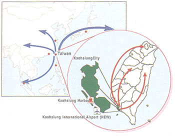 Osaka, Hong Kong,
Bangkok, Phuket, Peneng, Kuala Lumpur, Hanoi City, HoChi Ming City, Singapore, Laog,
Manila, Subic Bay and Guam. The mean minimum temperature for the coldest month, February,
is 18.6 degrees and maximum for the hottest month, July, is 28.7 degrees. The mean minimum
relative humidity in March is 60% and the maximum in August is 81%. There are 2,139 hours
of sunny days in a year; the minimum is 138.1 hours in February and the maximum is 227.4
hours in July. The annual rainfall is 1,134.1 mm. The lowest has zero mm in Dec. and the
highest has 569.1 mm in July.
Osaka, Hong Kong,
Bangkok, Phuket, Peneng, Kuala Lumpur, Hanoi City, HoChi Ming City, Singapore, Laog,
Manila, Subic Bay and Guam. The mean minimum temperature for the coldest month, February,
is 18.6 degrees and maximum for the hottest month, July, is 28.7 degrees. The mean minimum
relative humidity in March is 60% and the maximum in August is 81%. There are 2,139 hours
of sunny days in a year; the minimum is 138.1 hours in February and the maximum is 227.4
hours in July. The annual rainfall is 1,134.1 mm. The lowest has zero mm in Dec. and the
highest has 569.1 mm in July.
The beginning of history in the Kaohsiung area starts with the arrival of the Chenghe people at Fengshan in Taiwan in 1405. Chinese did not largely settle in Kaohsiung and set up a government until after Cheng Cheng-kung, known in the West as Koxinga, had expelled the colonial Dutch forces in 1661. Then Cheng built up Wan Nien County at Tsuoing, and brought Houching, Chienfeng, Yuchang, Tsuoing and Chiencheng under cultivation. As of May 1662, Cheng Ching, son and heir of Cheng, commissioned Cheng Yung-hua as the first governor. In 1664, Kaohsiung changed its name into Wan Nien Chow. In 1666 Cheng Ching adopted the suggestion of Cheng Yung-hua to institute the imperial examination system, which included two tests over a span of three years. Children started to take tests based on their age and this is the beginning of civilization in the area. In 1672 the place around Chihao was cultivated as well. During the Ching Dynasty, Kaohsiung was renamed Takao and an increasingly large number of Chinese settlers migrated to Taiwan at this time. In 1684 the Ching Dynasty began to directly govern Taiwan, also known by its Dutch name of Formosa. Formosa and Kaohsiung's name was again changed to be called Fengshan County in Taiwan City, and belonged to Fukien Province. The cultivation range was expanded into Chienchin, Takangpu, Wukuaichu, Litsunei and Lingyaliao districts. In the early Tungchih year of the Ching Dynasty, Takao was opened for the first time as a trading port, and Hsiaochuantou and Chihou became ports as well. Thus, Kaohsiung gradually transformed into a very important city on Taiwan. During the time of the Japanese Occupation, the Japanese implementedambitious plans for port construction and urban development. Furthermore, they set up Kaohsiung Townon Oct. 1, 1920 and turned it into the city of Kaohsiung on Dec. 25, 1924. After retrocession( the returnto Chinese rule), Kaohsiung City has gradually developed into the second biggest city in Taiwan.
The municipal government is composed of two separate entities: the city government and the city
council. The city councillors are popularly elected to 4 year terms. The mayor is also
popularly elected to a four year term. The mayorship was popularly elected for the first
time in 1990 and before that the position was appointed by the ROC government in Taipei.
Head Official: Mayor Wu Den-yih ( KMT ) ( appointed in 1990, directly elected in 1994;
current term expires in 1998 ) Total number of city employees: 24,362 ( 1993 )
the city government and the city
council. The city councillors are popularly elected to 4 year terms. The mayor is also
popularly elected to a four year term. The mayorship was popularly elected for the first
time in 1990 and before that the position was appointed by the ROC government in Taipei.
Head Official: Mayor Wu Den-yih ( KMT ) ( appointed in 1990, directly elected in 1994;
current term expires in 1998 ) Total number of city employees: 24,362 ( 1993 )
Major Industries and Commercial Activity The Port of Kaohsiung, strategically located on the southwestern coast of Taiwan and facing the key Southeast Asian trading lanes that run through the Taiwan Straits and the Bashi Channel, is the largest international sea port on Taiwan, ROC. The harbor is spacious with a 27 square kilometer hinterland. This expansive area, with a pleasant climate, a long sandbar that serves as a a natural breakwater and good location which make Kaohsiung a natural port. The port of Kaohsiung provides a worldwide sea link with all of the important ports in the world and is actively used by 109 countries. It handles around 80 million tons of exports and imports annually. This makes up 2/3 of the total cargo for all of Taiwan. In 1996, the tonnage reached 260 million tons. Most of the import cargoes were natural resources such as energy materials, while the main exports were chemical products. The main import cargoes came from Australia, USA, Saudi Arabia and Japan. The main export destinations were Hong Kong, Japan and the USA. In the same year, the container throughput of 5,063,048 TEUs has made Kaohsiung the world's third largest container port.
Industry Kaohsiung's natural attributes also make it the center of industry in Taiwan. It has favorable terrain, a wide inland area and excellent communications. The state run China Steel Corporation is the center of the island's steel industry, the Chinese Petroleum Corporation is the leader in the field of petro-chemicals and China Shipbulding dominates its industry. However, it is the cement industry in Kaohsiung that has the greatest capacity of all. These four industries, added to the Kaohsiung and Nantsu Export Processing Zones form the nucleus of Kaohsiung's rise to become Taiwa' center of productivity, industry and commerce.
資料來源:高雄市政府資訊中心